


1. 18 August 1926 – East of Palel, Manipur (Indo-Myanmar Border region), 6.0(TS) 23:58:48 UTC, 24.50N, 94.50E.
2. 20 May 1927 – Near Kangpat, Manipur (Indo-Myanmar Border region), 6.0(TS) 10:51 UTC, 24.50N, 94.00E
3. 11 July 1930 – North of Imphal, Manipur, 6.0 (TS) 07:06:34UTC, 25.00N, 93.80E
4. 22 September 1930 – Near Karong, Manipur, 6.0 (TS) 14:19:14 UTC, 25.30N, 93.80E
5. 2 June 1934 – East of Ukhrul, Manipur (Indo-Myanmar Border region), 6.5(TS) 05:04:27 UTC, 25.10N, 94.70E
6. 23 April 1935 – East of Ukhrul, Manipur(Indo-Myanmar Border region), 6.0 (TS) 16:45:41 UTC, 25.10N, 94.70E
7. 9 September 1937 – East of Ukhrul, Manipur(Indo-Myanmar Border region), 6.0 (TS) 23:37:27 UTC, 24.90N, 94.70E
8. 6 May 1938 – East of Ukhrul, Manipur(Indo-Myanmar Border region), 6.5 (TS) 03:40:57 UTC, 24.90N, 94.70E
9. 21 May 1937 – SW of Kohima (Manipur-Nagaland Border region), 6.0 (TS) 16:12:02 UTC, 25.50N, 94.00E
10. 27 May 1939 – South of Palel, Manipur, 6.7 (TS) 03:45:37 UTC, 24.30N, 94.10E
11. 11 May 1940 – Near Imphal, Manipur, 6.0 (TS) 21:00:19 UTC, 24.90N, 94.10E
12. 8 March 1947 – East of Imphal (Indo-Myanmar Border region), 6.0 (TS) 14:33:05 UTC, 24.90N, 94.70E
13. 30 April 1952 – SE of Kohima (Manipur-Nagaland Border region), 6.0 (TS) 1:49:?? UTC, 25.500N, 94.500E
14. 7 November 1952 – SW of Kohima (Manipur-Nagaland Border region), 6.0 (TS) 04:33:57 UTC, 25.500N, 94.000E
15. 1 July 1957 – Near Moirang, Southern Manipur, 7.25 (TS) 19:30:22 UTC, 24.400N, 93.800E
16. 30 September 1983 – East of Ukhrul, Manipur (Indo-Myanmar Border region), Mb 6.0 (BKK) 10:39:27.0 UTC,25.0393N, 94.6695E, 60.3Kms depth
17. 5 March 1984 – East of Palel, Manipur (Indo-Myanmar Border region), Mb 6.2 (HFS) 21:26:42.0 UTC, 24.5160N, 94.6204E, 67.50kms depth
18. 6 May 1984 – NE of Aizwal (Manipur-Mizoram Border region), Mb 6.0 (HFS) 15:19:11.0 UTC, 24.2152N, 93.5256E, 31.60kms depth
19. 18 May 1987 – Near Karong, Northern Manipur, Ms 6.2 (PEK) 01:53:51.0 UTC, 25.2287N, 94.2076E, 52.80kms depth
20. 6 August 1988 – East of Imphal (Indo-Myanmar Border region), Mw 7.2 (HRV) 00:36:24.6 UTC, 25.149N, 95.127E, 91kms depth Three people were killed in this earthquake. Tremors were felt over much of eastern and noth-eastern India, Bangladesh, Bhutan, Eastern Nepal and Myanmar. Felt as far as Kolkata and Patna. Some damage was also reported from Homalin in northern Myanmar
21. 15 April 1992 – NW of Mawalik, Chin Division (Indo-Myanmar Border region), Mb 6.3 (HFS) 01:32:11.0 UTC, 24.2680N, 94.9275E, 130.90kms depth
22. 18 September 2005 – Myanmar-Manipur border, Mw 5.724.653 N, 94.807 E, D=82 kms, OT=07:26:00 UTCA moderate earthquake struck the Myanmar-Manipur border, on 18 September 2005 at 12:56 IST causing isolated minor damage to property in some parts of Manipur. The earthquake had a magnitude of Mb=5.7 and was felt at many places north-east India and Bangladesh as well as in tall building in northern Thailand.
23. 4 September 2009 – Myanmar-Manipur border, Mw 5.924.381 N, 94.712E, D=97.6 kms, OT=19:51:03 UTCA moderate earthquake struck the Myanmar-Manipur border, on 4 September 2009 at 01:21IST. It was felt widely in north-east India and in Bangladesh
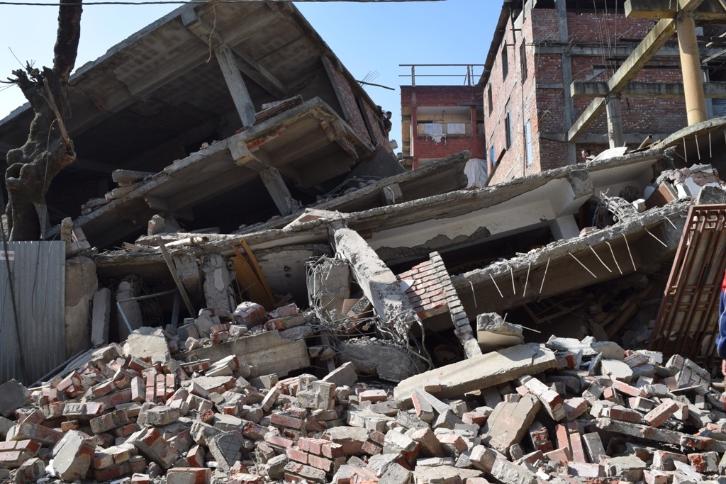
24. 4 Jan. 2016 – Epicenter-Noney, District Tamenglong 6.8 magnitude, 55 km depth Imphal, Manipur, India 8 dead,100+injured